
A total solar eclipse will cross North America on Monday, April 8, with the totality passing over Mexico, the U.S. and Canada. If you witnessed what some dubbed the "Great American Eclipse" of Aug. 21, 2017, which was over in about 2 minutes and 40 seconds, you’ll be glad to know that this time, the totality of the eclipse will last 4 minutes and 28 seconds, giving you just a little more time to see this phenomenon.
Ready to watch? NASA is making it easy to mark your calendar and find out what time the solar eclipse is happening where you live.
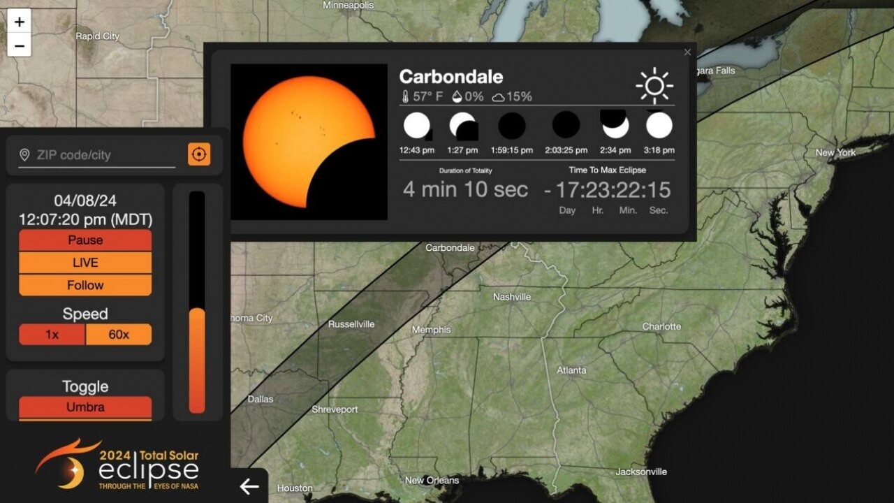
NASA’s Eclipse Explorer is an interactive map that shows when the eclipse will be visible in different areas. Just click on a city on the map, or enter your ZIP code on the left side of the map’s dashboard to find out what time to look to the skies. Hit play to see the moon progress across the sun’s path against the clock at your location.

Solar eclipse prompts National Guard response in Oklahoma
The Oklahoma National Guard is preparing to help local officials with an influx of visitors chasing the solar eclipse.
You can also see a prediction of the corona, the outermost part of the sun that can be seen during an eclipse, as well as compare this path to previous eclipses.
The path of the eclipse begins on Mexico’s Pacific coast around 11:07 a.m. PDT and exits continental North America on the Atlantic Coast of Newfoundland, Canada, at 5:16 p.m. NDT. In between those times, the eclipse will pass through Texas, Oklahoma, Arkansas, Missouri, Illinois, Kentucky, Indiana, Ohio, Pennsylvania, New York, Vermont, New Hampshire and Maine as well as small parts of Tennessee and Michigan. It will enter Canada in Southern Ontario and pass through Quebec, New Brunswick, Prince Edward Island and Cape Breton.
During the total eclipse, the moon passes between the sun and earth to completely block the face of the sun. The sky will become dark and look as if it were dawn or dusk. See more about how NASA’s map works in the video below:
NASA also provides a table that shows when the different stages of the eclipse can be viewed in several cities throughout the U.S.
The eclipse is certainly a sight to behold, but remember to put safety first. Be sure to protect your eyes by using special glasses that meet the International Organization for Standardization (ISO)12312-2. Check out American Astronomical Society for more safety tips. Happy eclipse viewing!
This story was originally published by Kate Streit at Simplemost.com.


